Moving ‘from Nexus thinking to Nexus doing’ requires providing decision-makers with detailed and reliable data, to help them make informed decisions that satisfy needs and optimise trade-offs between Nexus sectors. In the agricultural sector, which uses nearly 70% of freshwater resources globally, such reliable data is lacking; both public and private water managers usually take decisions based on rough statistical approaches or only a few water counters spread very thinly, due to the impracticality of maintaining a network of ground measurements over large areas.
Dr. Jesus Garrido, University of Castilla – La Mancha, explains how REXUS is changing the rules of the game, through the development of a new Remote Sensing-based Agricultural Water Accounting and Footprint methodology that can provide both public and private water managers with temporally and spatially precise information which they can tailor according to their needs. In fact, REXUS results for the Júcar River Basin in Spain, one of its pilot areas, have been adopted and published in the actual Júcar River Basin Management Plan.
Interviewed by GWP-Med, REXUS Communication and Dissemination leader.
- How does REXUS propose to consider the water sector within the Water-Energy-Food Nexus framework?
The importance of agricultural water use within the freshwater resources usages among human productive sectors is of greatest importance, since globally, the agricultural sector accounts for about 69% of freshwater resource use, while the industrial or the domestic sector accounts for about 19% and 12%, respectively (FAO, 2016). The REXUS project uses the latest remote sensing approaches that allow crop monitoring over large areas to estimate spatially and temporally distributed agricultural water usage data, while also collecting the latest water usage databases for domestic and industrial sectors, to develop an environmental footprint indicator that considers water usage by different human sectors and activities: the water footprint.
- Focusing on agricultural water usage, can you briefly explain what is ‘agricultural water accounting’ and ‘agricultural water footprint’ and why is it important to measure it?
Within the Water-Energy-Food Nexus framework, ‘agricultural water accounting’ and ‘agricultural water footprint’ are powerful complementary tools that can help and promote efficiency and sustainable water resource management in a way that satisfies present requirements without compromising future needs (UN, 2015).
First and within the REXUS framework, agricultural water accounting aims to quantify the water volume used by different crops. It can be applied, and therefore assess needs, at different management scales: at the level of a single plot, or the water user association, agricultural activities over a groundwater or river basin, and even at the level of wider surfaces, at national or international scale. Further, there is analysis over the temporal scale, which can help water managers to get information on temporal crop water use requirements at daily, weekly, monthly or for the entire crop cycle.
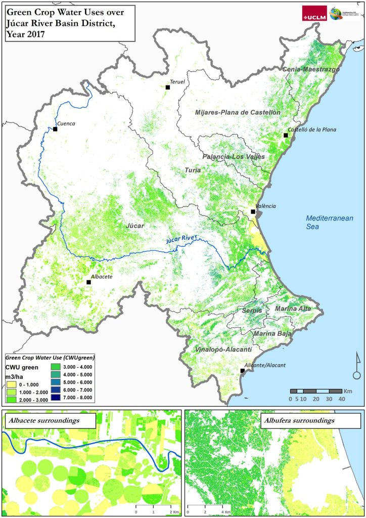
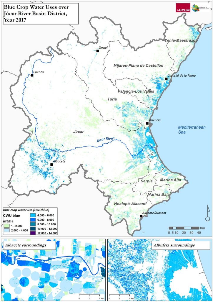
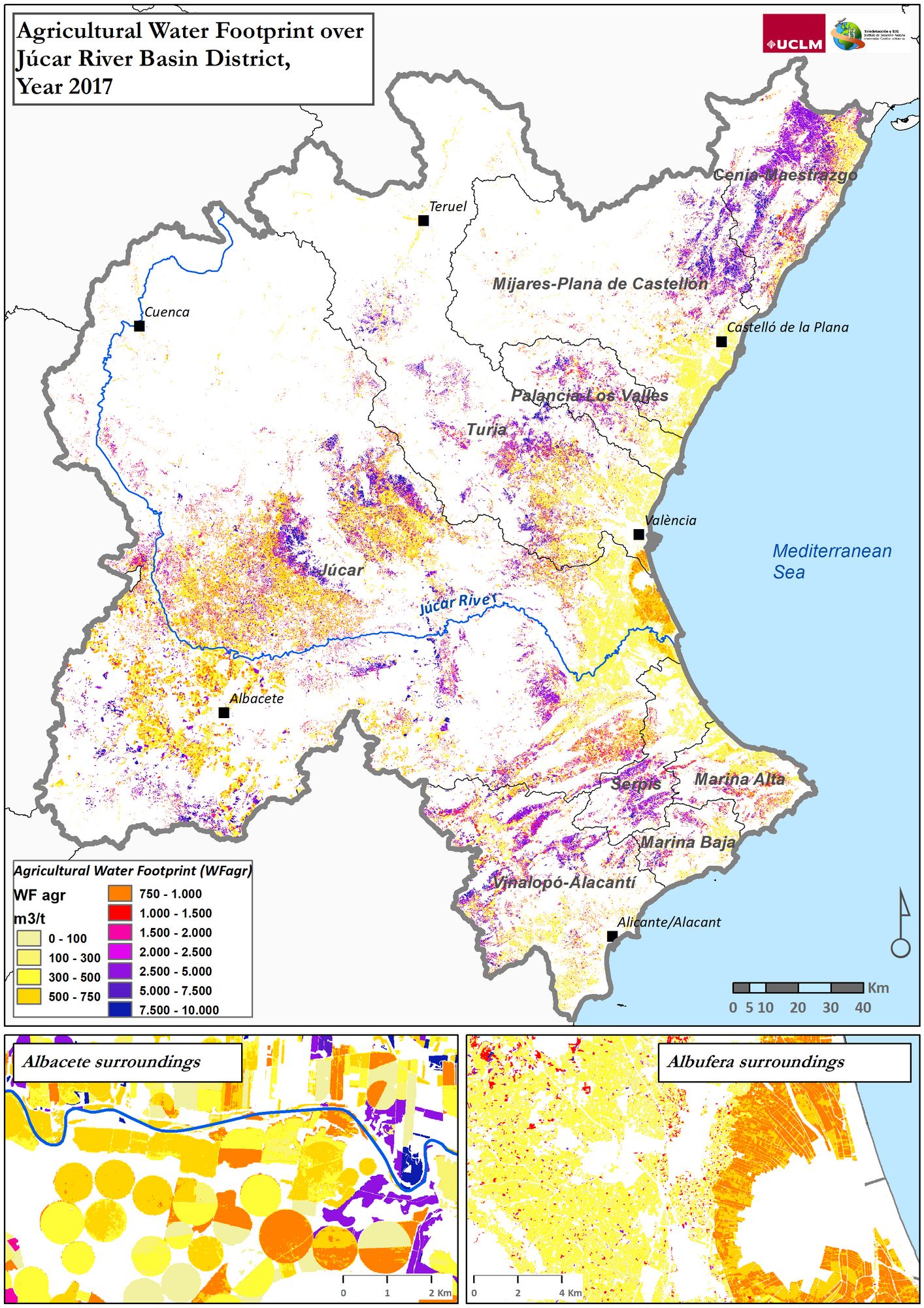
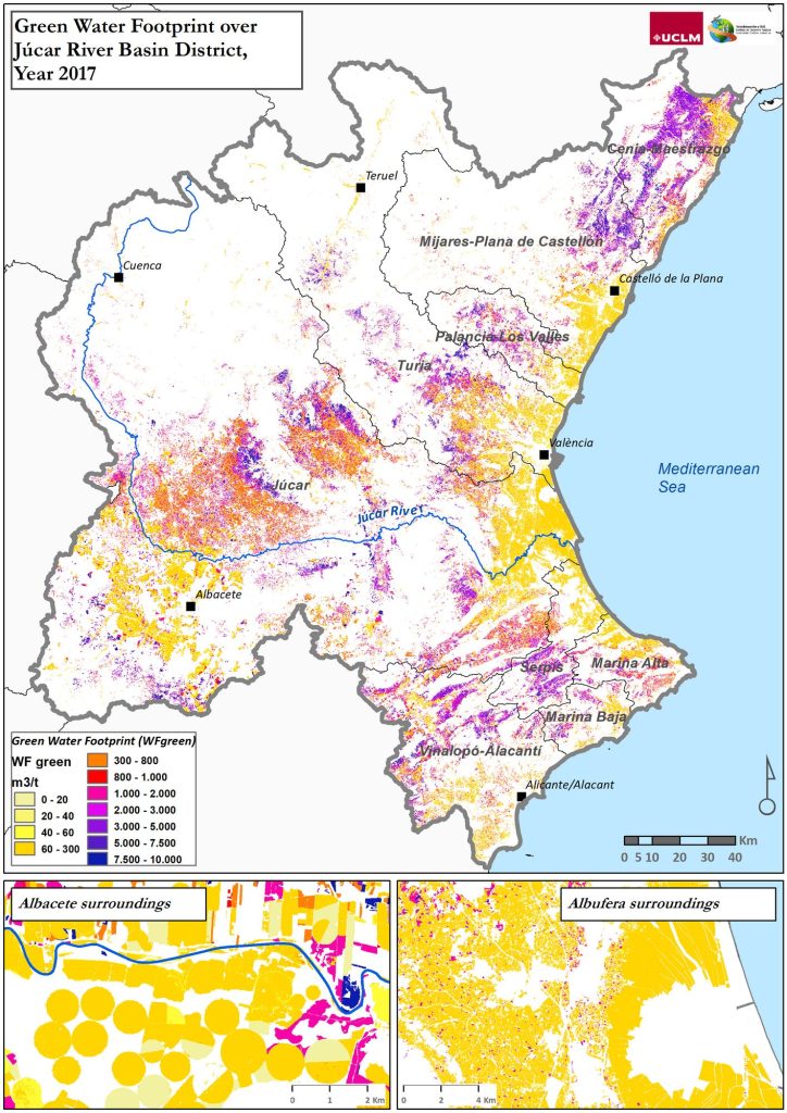
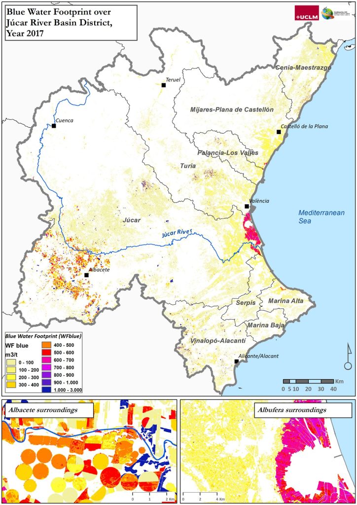
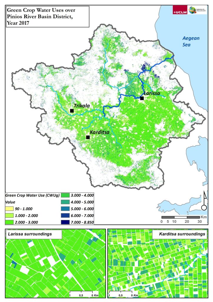
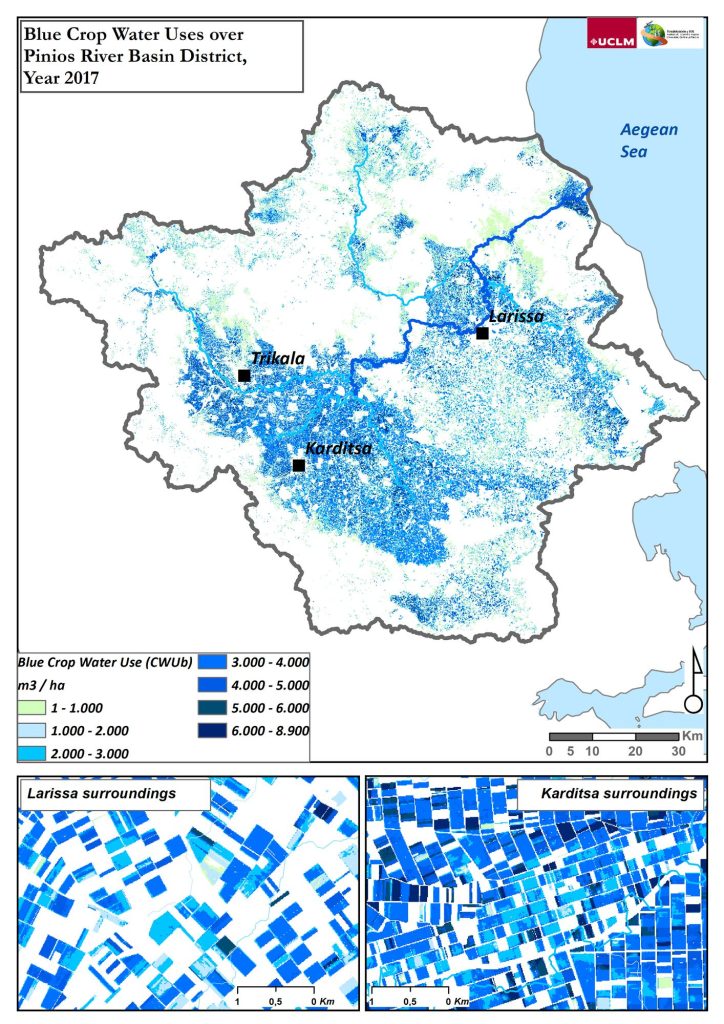
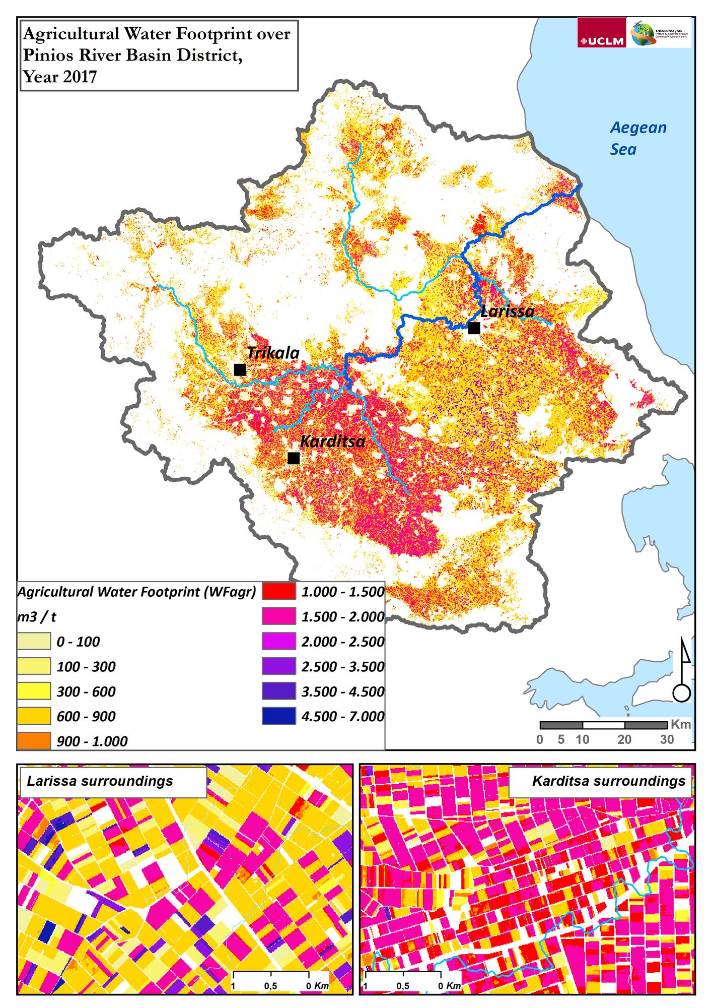
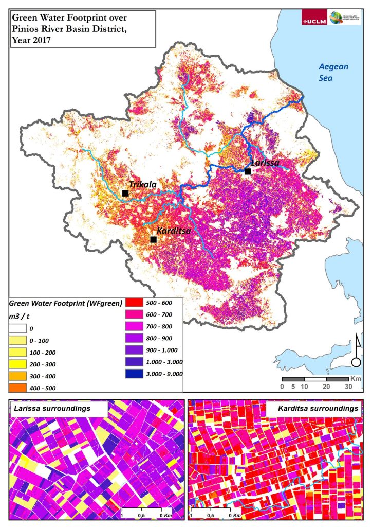
Secondary but complementary as well, the agricultural water footprint estimated over the crop cycle is defined based on the international standard proposed by the Water Footprint Network (Hoekstra et al., 2011) as “an indicator of freshwater use that looks not only at direct water use of a consumer or producer, but also at the indirect water use (…), that can be regarded as a comprehensive indicator of freshwater resources appropriation, next to the traditional and restricted measure of water withdrawal”. The agricultural water footprint is divided into blue water footprint (“surface or groundwater water resources consumption”), green water footprint (“rainwater insofar as it does not become run-off”) and grey water footprint (that is referred “to pollution and is defined as the volume of freshwater that is required to assimilate the load of pollutants given natural background concentrations and existing ambient water quality standards”).
The two concepts are closely related to each other since the second one needs the first to be estimated.
- How is the approach you have followed within REXUS different to traditional approaches?
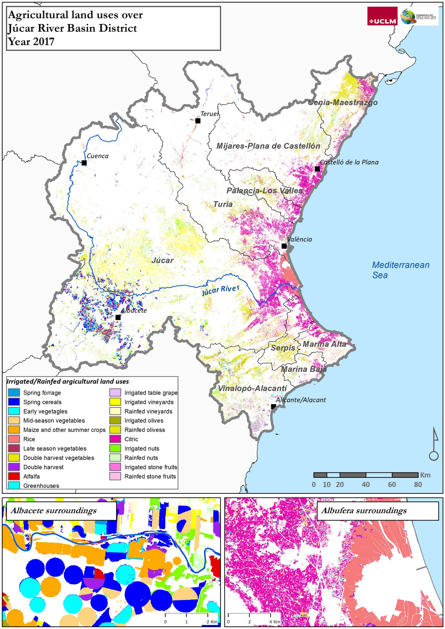
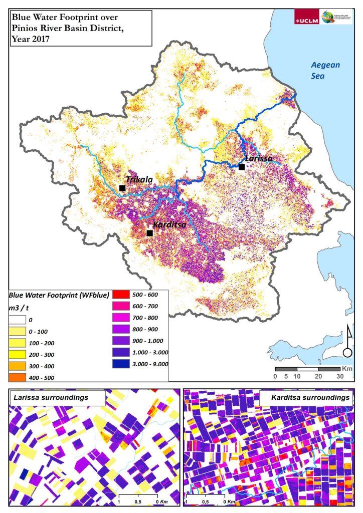
The methodology applied over the 5 REXUS pilot areas puts in both public and private water managers’ hands valuable spatial and temporal information rarely seen before: the thematical maps of different environmental indicators such as the green crop water use (precipitation water resource), the blue crop water use (superficial or groundwater resources), and the green and blue water footprint.
The REXUS approach to estimate the agricultural water accounting and footprint integrates Earth Observation data into two global, accepted and operative methodologies: the soil water balance to estimate crop evapotranspiration and net irrigation requirements, among other parameters (Allen et al., 1998), and subsequently includes these two previous parameters into the agricultural water footprint framework of growing a crop or tree (Hoekstra et al., 2011).
The REXUS approach novelty lies in the use of dense Sentinel-2 satellite image temporal series that allows crop monitoring over its complete cycle because data gathered over agricultural surfaces each week and converted into a vegetation index called NDVI provides a valuable resource for spatial and temporal crop track.
Therefore, the REXUS project offers a Remote Sensing-based Agricultural Water Accounting and Footprint methodology that generates detailed spatial and temporal knowledge about the agricultural water resources.
- What is the level of detail of the thematical maps that REXUS can provide to policymakers and users, and how reliable are they?
Spatial pixel resolution is 10m so they are perfect for displaying information for plots larger than 0.5 ha. Besides, this information can be spatially and temporally aggregated into the working scale desired by water managers.
For example, a river basin water manager can compile a report that covers each irrigation water user association enclosed in their river basin district. Hence, as this information can be related to the crops developed, the water manager’s knowledge of their territory is enhanced because the information regarding the quantity of green or blue water resource used or the green or the blue and green water footprint estimated of a specific crop in a specific water user association is included in those thematical maps or statistical reports.
Regarding reliability and accuracy of the results provided, the methodology is based on an Remote Sensing-based Soil Water Balance operative approach, in which the remote sensing assisted irrigation water accounting was positively validated at plot and water user association scale (Garrido-Rubio et al., 2020b), at groundwater management scale (Garrido-Rubio et al., 2019), and along different river basin districts over the Spanish mainland (Garrido-Rubio et al., 2020a). Furthermore, the Remote Sensing-based Agricultural Water Footprint has been positively evaluated with actual water footprint reports at river basin scales as can be consulted in a project deliverable called Deliverable 3.3 – Water Accounting and Footprint: Methodologies and Results.
- How can these tools help water managers and users make better decisions?
Due to the impracticality of maintaining a network of ground measurements over large areas, both public and private water managers usually take decisions based on statistical approaches that tabulate crop developments or on a few water counters spread over a large area territory. Hence, neither the actual crop behavior nor irrigation water accounting monitoring is calculated at the spatial resolution scale or at the temporal patterns that REXUS results offer.
- In line with the REXUS project’s aim is to move “from Nexus Thinking to Nexus Doing”, these water accounting/footprint tools were integrated into the Júcar River basin management plan, approved only a few weeks ago. Tell us what was the ‘secret’ of this success?
Indeed, we are very happy that these REXUS results over the Júcar River Basin have been published in the actual Júcar River Basin Management Plan, 3rd period 2022-2027. Within REXUS, the Remote Sensing & GIS group (https://www.uclm.es/grupos/teledeteccion-sig) from the Castilla – La Mancha University (UCLM) has been closely working with the relevant public water managers in subjects such as crop development, classification, and irrigation water accounting monitoring through remote sensing solutions. Hence, the path walked together is long and served for both public organizations to create bridges of trust between the latest scientific advances and agricultural crop and water resources management needs.
References:
Allen, R.G., L.S. Pereira, D. Raes, and M. Smith. 1998. Crop evapotranspiration – Guidelines for computing crop water requirements.
FAO. 2016. AQUASTAT – FAO’s Information System on Water and Agriculture. Food Agric. Organ. United Nations. http://www.fao.org/nr/water/aquastat/water_use/index.stm.
Garrido-Rubio, J., A. Calera, I. Arellano, M. Belmonte, L. Fraile, et al. 2020a. Evaluation of remote sensing-based irrigation water accounting at river basin district management scale. Remote Sens. 12(19): 3187. doi: 10.3390/rs12193187.
Garrido-Rubio, J., J. González-Piqueras, I. Campos, A. Osann, L. González-Gómez, et al. 2020b. Remote sensing–based soil water balance for irrigation water accounting at plot and water user association management scale. Agric. Water Manag. 238. doi: 10.1016/j.agwat.2020.106236.
Garrido-Rubio, J., D. Sanz, J. González-Piqueras, and A. Calera. 2019. Application of a remote sensing-based soil water balance for the accounting of groundwater abstractions in large irrigation areas. Irrig. Sci. 37(6): 709–724. doi: 10.1007/s00271-019-00629-3.
Hoekstra, A.Y., A.K. Chapagain, M.M. Aldaya, and M.M. Mekonnen. 2011. The Water Footprint Assessment Manual. Earthscan, London.
UN. 2015. 70/1. Transforming our world: the 2030 Agenda for Sustainable Development Transforming our world: the 2030 Agenda for Sustainable Development Preamble. General Assembly, New York.